Maps and Data
Find maps and charts showing transportation data and trends related to alternative fuels and vehicles.
OR
-
-
E85 Fueling Station Locations by State
Displays states and their respective E85 station counts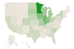
-
-
-
U.S. Ethanol Plants, Capacity, and Production
Trend of ethanol plant counts and production volumes from 1999 to 2022 Last update April 2024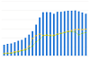
-

E85 Fueling Station Locations by State
| [object Object] |
| [object Object] |
| [object Object] |
| [object Object] |
| [object Object] |
| [object Object] |
| [object Object] |
| [object Object] |
| [object Object] |
| [object Object] |
| [object Object] |
| [object Object] |
| [object Object] |
| [object Object] |
| [object Object] |
| [object Object] |
| [object Object] |
| [object Object] |
| [object Object] |
| [object Object] |
| [object Object] |
| [object Object] |
| [object Object] |
| [object Object] |
| [object Object] |
| [object Object] |
| [object Object] |
| [object Object] |
| [object Object] |
| [object Object] |
| [object Object] |
| [object Object] |
| [object Object] |
| [object Object] |
| [object Object] |
| [object Object] |
| [object Object] |
| [object Object] |
| [object Object] |
| [object Object] |
| [object Object] |
| [object Object] |
| [object Object] |
| [object Object] |
| [object Object] |
| [object Object] |
| [object Object] |
| [object Object] |
| [object Object] |
| [object Object] |
| [object Object] |
Thousands of fueling stations across the country provide E85 for flex-fuel vehicles. Roll over a state on the map for a count of E85 fueling stations. To map E85 stations near a specific address or city, use the Alternative Fueling Station Locator. For station counts and historical information, see Station Counts by State.
Print